
When the trees are harvested, and the logs are distributed for production, the amount of labor cost and income from timber sales need to be estimated beforehand. For the estimations, it is essential to measure the size of trees accurately, including the number, height, and diameter of the trees. However, lowering the cost of high accuracy of manual measurement is a big challenge. An inexpensive, simple, accurate, and efficient method is required to measure forest over a large area.
Here, the development of drone measurement technology becomes a crucial application for smart forestry. The introduction of drones saves over 80% of labor costs and doubles the timber sale. It makes a significant impact on the sustainability of the forestry industry.
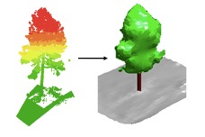
In our lab, we have been developing techniques using a laser to capture the 3D structure of trees. We have established a world-leading technique to analyze 3D data obtained from the laser within 5% of measurement errors. The 5% error was achieved by a unique neural network technique. We have also established a method to analyze multi-temporal 3D data automatically. We are working on an automatic time-series analysis of 3D data, which is needed for a higher frequency of 3D data acquisition near the future.
The functionality of current drones has been dramatically improved, and the flight has been stabilized. The demand from agriculture and forestry fields should be reflected in drone development. We work closely with engineers who can make drones and keep developing technology suitable for forest survey. With our creative mind, our drone's future application is under development for the next 30 years.
Reference
- Capturing Tree Crown Formation through Implicit Surface Reconstruction using AirborneLidar Data, Kato, A., Moskal, L.M., Schiess, P., Swanson, M.E., Calhoun, D., and Stuetzle, W.,Remote Sensing of Environment113, pp. 1148-1162, 2009
DOI: 10.1016/j.rse.2009.02.010
Profile
Akira Kato
Received a Ph.D. from School of Forest Resources, University of Washington in 2008. Since then, has been a faculty at the Graduate School of Horticulture of Chiba University. Specializes in understanding plant and tree structure using high-resolution 3D lasers. He also applies 3D data for natural disasters (e.g. forest fires) to study ecological processes and understand the adaptation of nature for the disaster.